
Cortlandt Previous Residents by Era
The best source changes with the period. A current parcel card supplies the modern starting point. Recorded deeds extend far earlier, but identify legal transfers rather than every occupant. Directories, census schedules, newspapers, and maps add the household and place layers. For a Cortlandt address near a village or Peekskill, first verify which municipality held the parcel. Postal wording alone does not decide the correct custodian.
| Source | Years It Covers | Where Held | What It Shows |
|---|---|---|---|
| CAI Property Card | Current data; GIS PRCs became static after June 1, 2024 | Town Property Data Search | Current owner information, sales or transfers, mailing addresses, and parcel-card categories |
| Westchester Records Online | Eighteenth-century deeds to current records | Westchester Records Online | Free index access; images and reports require an account and paid remote access |
| County and Peekskill directories | Gopsill 1866; Curtin's 1868-1873; Peekskill films through 1940-1942 in located runs | County repositories and New York State Library | Published household, place, or business listings, depending on the title |
| Federal and state census schedules | Federal schedules 1790-1950; New York material identified for 1905, 1915, and 1925 | National Archives and research repositories | Household and enumeration context, with a known 1890 federal gap |
| Historic maps and notices | 1868 Beers atlas; 1911 Sanborn coverage in named local areas; title-specific newspaper runs | Map and library collections | Roads, landowners, structures, and dated local notices |
Use the newest reliable parcel record to identify the legal property first. For an older period, switch to the deed, map, directory, or census source that actually reaches that era. Note: A tax owner, deed party, and directory line are separate forms of evidence and should not be merged into one claim.
Cortlandt Past Residents Start CAI
The Town's Property Data Search links to the current CAI Property Card and is the right first stop for a modern address. Town guidance says the current card carries current owner information, sales or transfers, and mailing addresses. Record the situs address, the section, block, and lot if available, every owner name, the transfer reference, and the date before opening older sources.
The distinction between the current card and older material is important. Hard-copy property record cards stopped being updated or uploaded to GIS on June 1, 2024, so GIS PRCs are static or historic. An old card can help document an earlier point, but a missing new transfer there does not disprove a current transfer. When an address search fails, the Assessor can provide section and block information from an address or owner name at 914-734-1040.
Cortlandt Previous Residents Deed Trail
Westchester Records Online, often called WRO, is the County Clerk's land, legal-record, and maps entry point. Its notice describes coverage from eighteenth-century deeds to current records. Search the narrowed party name, municipality, approximate period, and recorded reference when available. The index search is free. Remote images and reports require registration and paid access, while the County Clerk can provide the official route for a certified copy.
- Open the current CAI card and write down the modern situs address, parcel identifiers, owners, and transfer details.
- Use the purchaser's name and the available period in WRO to locate the recorded transfer, then preserve its parties and any document or book and page reference.
- Move to the earlier party's acquisition record, checking the grantor and grantee roles against the document rather than relying on a name alone.
- Repeat the process backward while comparing the legal description, map reference, road name, and parcel identifiers at every link.
- When the online result needs proof, obtain the image or certified copy through the County Clerk before treating the link as settled.
- Shift to the County Archives reading room, archival deed books, maps, or microfilm when the trail reaches an older series.
- Grantor
- The party transferring the recorded property interest in a deed.
- Grantee
- The party receiving the recorded property interest in a deed.
- Chain of title
- The sequence of recorded transfers used to follow a property interest backward through time.
- Legal description
- The deed's lot, map, road, or prior-owner wording that identifies land when a street number changes.
WRO describes its online material as a separate database that is updated periodically and does not warrant accuracy, currency, or completeness. Treat an index hit as a lead to the recorded item. A certified County Clerk copy, when needed, is the official document route.
Cortlandt Past Residents Legal Descriptions
Old road names and changing address formats can break a simple number search. A legal description provides the better crosswalk because it may name a lot, map reference, road, or former owner. Compare it with the section, block, and lot from the assessor record, then test it against the County Clerk historical maps or the 1868 atlas. Do not force a match just because a street name sounds familiar.
The physical situs address and a mailing address also need separate treatment. A situs address identifies the parcel. A mailing address can be a different residence, post-office box, bank, trust, representative, or tax-bill destination. That difference is why a parcel card gives a starting point for past residents, not a complete household list.
Cortlandt Maps Before Numbers
The 1868 Beers Westchester atlas names landowners, roads, buildings, and business material for the Town of Cortlandt, Cortlandtville, and Croton Landing. It is a practical crosswalk for a deed that gives a road or owner name rather than a modern street number. A map label remains a historical clue, not proof that a person lived there through a whole period.
The Library of Congress 1911 Peekskill Sanborn volume includes Verplanck and part of Buchanan. Use it to place a built structure or street pattern alongside the earlier atlas and a deed reference. No separate Sanborn volume for all Town hamlets was located, so an absent map result is not evidence that the building or household did not exist.
Cortlandt Previous Residents Households
Ownership is only one layer. A former owner may not have occupied the parcel, while a household can appear in a directory, census, newspaper notice, or church record without holding title. The historical collection detail belongs with the Cortlandt city directory; here, use a confirmed directory year as one step in an address trail and test it against the closest census, map, deed, or notice.
The New York State Library directory microfilm list identifies the located Peekskill runs that can catch a Cortlandt-area household when the printed municipality and address fit. The dated films are a useful starting point for former occupants, especially when a county run or local newspaper fills a gap.
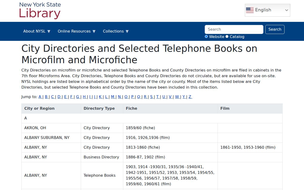
The directory list shows why an address trail must be built around specific years rather than an assumed annual run. Match the year to the title, then preserve the page citation and compare the printed line with another record.
- Choose the confirmed directory year nearest the property event or household question.
- Copy the name, printed place, year, title, page, neighboring lines, and spelling exactly as published.
- Pair it with the nearest federal or New York State census schedule and its enumeration district.
- Compare the place line with a map or deed to decide whether the record points to the same parcel.
- Use a newspaper, obituary, church record, or probate source only as a dated follow-up, not as a substitute for the address evidence.
Cortlandt Census Pairing Gap
The federal census runs through 1950 under the 72-year release rule, but the 1890 schedules were mostly destroyed in a 1921 Commerce Department fire. For a household that crosses that period, compare the 1880 and 1900 federal entries with county directories, maps, deed recordings, and newspaper notices. New York State microfilm for Westchester adds 1905, 1915, and 1925 schedules, though its questions differ from the federal form.
A simple pairing flow is: dated directory line to closest census, census household to parcel or road, parcel to deed or map, then notice or obituary only where it confirms the timeline. This preserves the difference between a household entry and a property transfer. The 1890 loss is a documented gap, so leave that interval open when the sources do not connect it.
Cortlandt Previous Residents Permit Trail
Building permits and certificates of occupancy can date a change to the parcel and may contain applicant, owner, agent, site, and permit fields when the record is disclosable. Town Code Enforcement handles permits, demolition, certificates of occupancy, inspections, and related functions. The Town's OpenGov route is verified for application and complaint submission or tracking, but the research did not confirm a public case-search screen.
For a specific past record, ask Code Enforcement or submit a focused Town FOIL request that names the address, permit number or type, and date range. The Town FOIL page routes property-card and tax-history questions and notes that septic information is maintained by Westchester County. A permit can help date construction or an alteration. It does not, on its own, prove that the applicant lived at the address.
Cortlandt Archive Routes
When WRO, a directory film, or a parcel card ends, switch channels rather than repeating the same search. The County Clerk counter handles current certified documents. The County Archives reading room holds deeds, wills, naturalizations, maps, photographs, and government material alongside Historical Society resources. Visitors need identification, a researcher application, and call slips, and current hours should be confirmed.
Archives mail research is designed for a record already identified in an index. Field Library's local-history holdings and digitized newspapers can help find that citation. The Cortlandt Historical Society may hold local photographs, papers, and history that are not catalogued online. For a family trail before civil registration, church, cemetery, census, deed, newspaper, and probate evidence can be compared, with each source kept in its own dated layer.
Note: A missing online result may reflect a repository, format, or jurisdiction limit, so retain the parcel and citation details for the counter or reading-room request.